- Aloitussivu /
- Elektroniikka /
- GPS, Finders & Accessories /
- Sports & Handheld GPS /
- Handheld GPS Units /
- PPK, NOAA RTK GNSS Survey Equipment GPS Recei...
0 ratings


Tuotteen numero:
143127275
PPK, NOAA RTK GNSS Survey Equipment GPS Receiver with IMU Rover & Base Handheld Collector Land Surveying Equipment, Survey Software(Include
91% vastaajista suosittelisi tätä ystävälle
Tuotteen numero:
143127275
€ 2851
Hintatiedot
Ei sisällä toimitus- ja tullimaksuja ( Toimitus- ja tullimaksut lasketaan kassalla )
*Kaikki tuotteet tuodaan maasta Yhdysvallat
0 ratings
Kirjoita arvostelu
Varastossa
 Tuotu myymälästä paikasta USA
Määrä:
Tilaa nyt ja saat sen noin Lauantai, Lokakuu 10
Suojattu tapahtuma
Ubuy tekee kovasti töitä turvallisuutesi ja yksityisyytesi suojaamiseksi. Kehittynyt maksun turvallisuusjärjestelmämme varmistaa luottamuksellisuuden salaamalla tietosi siirron aikana AES (Advanced Encryption Standards)- ja SSL (Secure Socket Layer) -protokollilla. Maksutietosi ovat 100 % turvassa, sillä emme jaa maksutietojasi kolmansien osapuolten myyjille.
Tärkeimmät logistiikkakumppanimme


Unsurpassed Precision: Our RTK technology ensures centimeter-level accuracy, providing you with reliable measurements for the most demanding surveying tasks.

Osta nyt, maksa myöhemmin

Fast
Shipping

Ilmainen
palautus*

Pakattu turvallisesti

100-prosenttisesti alkuperäistuotteita

PCI DSS Compliance

ISO 27001 Certified




Note: Step Down Voltage Transformer required for using electronics products of Yhdysvallat store (110-120). Recommended power converters Osta nyt.


Mikä erottuu joukosta
Precision GNSS
Utilizes NOAA RTK technology for high-accuracy land surveying, minimizing errors in data collection, making it ideal for professionals requiring exact measurements.
Integrated IMU
Includes an Inertial Measurement Unit for enhanced stability and accurate positioning in challenging environments, significantly improving survey results over traditional methods.
Comprehensive Package
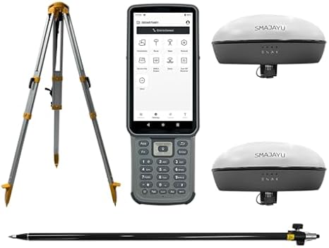
Complete solution with GPS receiver, handheld collector, pole, tripod, and survey software, providing everything needed for effective land surveying in one convenient package.
Tuotteen yksityiskohdat
| Additional Features | Lightweight |
| Compatible Devices | Smartphone |
| Brand | SMAJAYU |
| Model Name | Surveying Equipment |
| Built-In Media | GNSS Receiver, Handheld Collector, Other accessories, Surveying Pole, Surveying Tripod |
| Manufacturer | SMAJAYU |
| Number of Items | 1 |
| Model Number | SMA20 |
| Mfr Part Number | SMA20 |
| Special Feature | Lightweight |
| Included Components | GNSS Receiver, Handheld Collector, Other accessories, Surveying Pole, Surveying Tripod |
| Item Weight | 7.2 lbs (3.27 kg) |
Kenelle sopii?

-
Professional Surveyors
Ideal for experienced surveyors needing precise location data for large land projects with high accuracy requirements.
-
Geospatial Engineers
Great for geospatial engineers working on mapping and designing infrastructure projects requiring advanced GNSS technology.
-
Agricultural Planners
Beneficial for agricultural planners looking to optimize land use and crop monitoring with reliable GNSS support.

-
Casual Users
Not suitable for casual users needing simple location data, as it offers complex features not necessary for basic use.
TUOTEKUVAUS.
PPK, NOAA RTK GNSS Survey Equipment GPS Receiver with IMU Rover & Base Handheld Collector Land Surveying Equipment, Survey Software(Include Pole,Tripod)
Onko sinulla kysyttävää? Keskustele kanssamme
Asiakkaiden kysymykset ja vastaukset
-
kysymys:
What is the PPK, NOAA RTK GNSS Survey Equipment GPS Receiver used for?
vastaus: The PPK, NOAA RTK GNSS Survey Equipment GPS Receiver is designed for high-precision land surveying tasks. It provides real-time kinematic (RTK) positioning, ensuring accuracy in data collection for applications like topographic mapping, construction layout, and geospatial analysis. This equipment is critical for professionals needing reliable geolocation data, such as civil engineers, land surveyors, and environmental consultants, allowing for effective project planning and execution. -
kysymys:
How does the IMU enhance the performance of the GNSS Receiver?
vastaus: The Inertial Measurement Unit (IMU) integrated into the GNSS receiver enhances positioning accuracy by compensating for satellite signal outages and providing orientation information. It enables the system to maintain position and orientation data during dynamic conditions, such as when a surveyor is moving. This is particularly useful for projects that require mobility, like aerial surveys or large-scale site mapping, as it ensures continuous data integrity. -
kysymys:
What is included with the GNSS Survey Equipment package?
vastaus: The GNSS Survey Equipment package typically includes the PPK receiver, IMU rover, base station, handheld collector, and essential accessories such as a pole and tripod. This comprehensive set ensures that users have everything they need to begin surveying right away. The pole and tripod help stabilize the equipment, ensuring accurate data collection in various terrain conditions, making it well-suited for both urban and rural projects. -
kysymys:
Can this equipment be used for hydrographic surveying?
vastaus: Yes, the PPK, NOAA RTK GNSS Survey Equipment can be effectively used for hydrographic surveying. Its high-precision capabilities allow for accurate underwater positioning and mapping, which is essential for projects such as dredging, marine construction, and environmental monitoring. By integrating with specialized software, users can create detailed bathymetric maps, enhancing the effectiveness of waterway management and marine research. -
kysymys:
What types of survey software are compatible with this equipment?
vastaus: The GNSS Survey Equipment is compatible with various survey software solutions designed for processing GNSS data. Users can utilize software such as Trimble Business Center, Leica Geo Office, or generic data processing tools that support RTCM formats. These software solutions facilitate data post-processing, enabling users to generate accurate survey reports and digital elevation models essential for project analysis and decision-making. -
kysymys:
How do I setup the base station with the rover?
vastaus: Setting up the base station with the rover involves positioning the base station at a known control point and configuring its settings to broadcast correction signals. The rover, once positioned at the survey site, receives these signals to improve positional accuracy. This configuration is vital for achieving centimeter-level accuracy in land surveying, especially in applications like boundary surveys and construction stakeouts where precision is crucial. -
kysymys:
Is the equipment portable for field use?
vastaus: Yes, the PPK, NOAA RTK GNSS Survey Equipment is designed for portability, making it suitable for field use. The handheld collector is lightweight and can be easily carried, while the collapsible tripod and pole facilitate efficient setup in various environments. This portability is essential for professionals conducting surveys across large sites or remote areas, ensuring they can efficiently gather data without cumbersome equipment. -
kysymys:
What is the accuracy level of the GNSS Receiver?
vastaus: The PPK, NOAA RTK GNSS Survey Equipment GPS Receiver achieves accuracy levels often within 1-2 cm, depending on environmental factors and configuration. This high level of precision is critical for land surveying tasks requiring detailed data collection, such as legal boundary determination, topographic mapping, and infrastructure development. The robust performance in diverse conditions ensures reliable results for professionals across multiple industries. -
kysymys:
What type of batteries does the GNSS Receiver use?
vastaus: The GNSS Receiver typically uses rechargeable lithium-ion batteries, ensuring a reliable power source for extended surveying tasks. These batteries are designed for longevity and can sustain prolonged use in the field. With the ability to recharge quickly, surveyors can efficiently manage their time and workload, particularly during comprehensive surveying projects, minimizing downtime while ensuring continuous operation. -
kysymys:
Where can I buy PPK, NOAA RTK GNSS Survey Equipment GPS Receiver in Finland?
vastaus: You can buy the PPK, NOAA RTK GNSS Survey Equipment GPS Receiver, including the IMU rover and base handheld collector, from Ubuy in Finland. Ubuy is known for its extensive collection of high-quality surveying equipment and offers convenient purchasing options for professionals in need of reliable GNSS solutions.
SMAJAYU Handheld GPS Units SMA20 Editorial Review
PPK, NOAA RTK GNSS Survey Equipment GPS Receiver with IMU Rover & Base Handheld Collector Land Surveying Equipment, Survey Software(Include Pole, Tripod) is a highly regarded tool for precision surveying. With its lightweight design, weighing only 7.2 lbs, it's designed for easy handling during fieldwork. This device includes essential components such as a GNSS receiver, a handheld collector, and surveying accessories like poles and tripods, making it versatile for land surveying tasks. Users have noted the seamless compatibility with smartphones, enhancing its functionality for digital integration. This equipment is perfect for professionals seeking accuracy and efficiency in their surveying projects.
Asiakkaiden arvostelut ja arvosanat
1 asiakkaiden arvosanat
-
5 tähteä
0%
-
4 tähteä
100%
-
3 tähteä
0%
-
2 tähteä
0%
-
1 tähteä
0%
Arvostele tämä tuote
Jaa ajatuksesi muille asiakkaille
Plussat
- Lightweight for easier handling during surveys
- Compatible with smartphones for enhanced functionality
- Includes essential surveying accessories
- Built-in GNSS receiver ensures high precision
- Ideal for professional land surveying tasks
Miinukset
- User manual could be more comprehensive in details
LUOTTAMUS JA OSTAJAN TURVA

JK
Jasmin
Vahvistettu ostaja
“Great products and very good service: very easy and very fast international delivery.”
9 September 2026 · via Trustpilot
AG
Anke
Vahvistettu ostaja
“Wonderful online shopping experience, smooth transaction from the start. Payment method works conveniently and delivery is unexpectedly fast and reliable. You go the extra mile for service. What makes this even more amazing, you deliver to Namibia. I will remain a happy Ubuy customer and will increase my purchases for sure! Thank you!”
10 September 2026 · via Trustpilot
H
Hazel
Vahvistettu ostaja
“Very easy to find the products what you need, and so fast delivery, that’s why I highly recommended to others costumers to used ubuy.”
10 September 2026 · via Trustpilot
O
Opaleye
Vahvistettu ostaja
“I received exactly what I ordered I was skeptical about your site because that was my first time to order. But the order came timely and neatly packaged. I was not disappointed. Thank you.”
11 September 2026 · via Trustpilot
AC
Adele
Vahvistettu ostaja
“Easy to find and order what you want on the website. Delivery is quick to the UK”
8 September 2026 · via Trustpilot
Turvallinen kassatapahtuma
Maailmanlaajuinen toimitus
Helpot palautukset
Aidot tuottee
Tuotteen hintahistoria
Tärkeitä tietoja
- Rajoitukset: Kansainvälisesti toimitettujen tuotteiden kohdalla tulee ottaa huomioon, ettei valmistajan takuu välttämättä ole voimassa, etteivät valmistajan huoltovaihtoehdot välttämättä ole käytettävissä, etteivät tuotteen ohjekirjat, oppaat ja turvallisuusvaroitukset välttämättä ole kohdemaan kielellä, ettei tuotteita (ja niiden oheismateriaalia) ole välttämättä suunniteltu vastaamaan kohdemaan standardeja, teknisiä tietoja ja merkintävaatimuksia ja etteivät tuotteet välttämättä vastaa kohdemaan jännitettä ja muita sähköstandardeja (jolloin ne saattavat tarvittaessa vaatia sovittimen tai muuntimen käyttöä). Vastaanottaja on vastuussa sen varmistamisesta, että tuote voidaan toimittaa kohdemaahan laillisesti. Kun vastaanottaja tekee tilauksen Ubuysta tai sen kumppanuusyhtiöiltä, hän on myös rekisteröity maahantuoja ja hänen tulee noudattaa kaikkia kohdemaan lakeja ja säädöksiä.
- Kaikki Ubuyssa listatut tuotteet eivät ole myytävänä, koska Ubuy on maailmanlaajuinen hakukone. Tuotteisiin kohdistuu vienti- ja myyntisäännöksiä.
€ 2851
Tilaa nyt ja saat sen noin Lauantai, Lokakuu 10
This item is not restrict in my country.(Please click on above link if this item is not restrict in your country, So our team will review and allow.)
Määrä:
Suojattu tapahtuma
PCI DSS -yhteensopiva ja ISO 27001:2022 -sertifioitu, salatut maksut ja täysi ostajansuoja jokaisella tilauksella.
Tärkeimmät logistiikkakumppanimme
Nopein rajat ylittävä toimitus
Ominaisuudet ja hyödyt
- Achieve centimeter-level accuracy with advanced RTK technology.
- Ideal for topographic, geographic, engineering, and agricultural surveying.
- NOAA certified for reliability and performance.
- PPK capability allows for operation in challenging environments up to 25km.
- Supports multiple constellations for versatile applications.
- Data output compatible with various formats for easy integration.
Ubuy-takuu
Nauti huolettomasta ostoskokemuksesta: 100 % alkuperäisiä tuotteita, PCI DSS -yhteensopiva maksuturvallisuus, ISO 27001 -sertifioitu tietosuoja, nopein rajat ylittävä toimitus, ilmaiset palautukset ja turvallinen pakkaus jokaisella tilauksella.